
The Ultimate 2 Week National Park Roadtrip from Coast to Coast
This ambitious itinerary leads you through some of our nation’s best parks, so please remember to follow all park rules, keep a distance from wildlife, and Leave No Trace. This post may contain affiliate links that I’ve hand-selected. I may receive a small commission at no cost to you if you purchase through these links, so thank you for your support!
This coast to coast national parks road trip brings you to some of the country’s best wilderness landscapes. Replace skylines with rising mountain peaks in the Great Smokies and Rockies and journey deep into the cavernous Mammoth Cave. Witness the engineering ingenuity of the famous Gateway Arch and wander paths along the Oregon Trail still textured with wagon ruts.
Next, explore Chimney Rock, then marvel at the formations and landscapes in Arches and Great Basin national parks. Wrap up your two-week adventure in Sequoia National Park among the world’s tallest trees before visiting Yosemite and its rugged granite formations, falls, and meadows.
14-Day Coast to Coast National Parks Road Trip Overview
This exciting 14-day road trip includes the following stops and parks:
- Fly into Knoxville, TN
- Great Smoky Mountains National Park, TN
- Mammoth Cave National Park, KY
- Gateway Arch National Park, MO
- Santa Fe Trail Park, KS (Oregon National Historic Trail)
- Chimney Rock National Historic Site, NE
- Rocky Mountain National Park, CO
- Arches National Park, UT
- Great Basin National Park, NV
- Sequoia National Park, CA
- Yosemite National Park, CA
- Fly out of Fresno, CA
You’ll fly into Knoxville, TN (McGhee Tyson Airport), rent a car, and drive 45 miles east to the Great Smoky Mountains National Park. Moving westward, you’ll travel through 9 states to visit incredible parks and historic sites.
I’m sharing some ideas for each park and stop along the way — scenic trails and drives, rock formations, waterfalls, landmarks, world record trees, and more.

Day 1: Great Smoky Mountains National Park via Knoxville, TN
Exploring Great Smoky Mountains National Park is the perfect way to start your coast to coast national parks road trip! Coming in through the Gatlinburg entrance, grab a parking pass (required) and drive the curvy 31-mile Newfound Gap Road to Cherokee, NC to see some of the park’s coolest highlights.
Newfound Gap Road, Gatlinburg Trail, and Cataract Falls
Get on the Gatlinburg Trailhead near the Sugarlands Visitor Center on Newfound Gap Road for a quick walk through the forest that leads to old cabins, a footbridge over the Little Pigeon River, and Cataract Falls.
Continue along and pull off at the Chimney Tops Overlook, close to the Chimneys Picnic Area — the best place to pull over and eat some sandwiches or snacks with panoramic mountain and forest views.
The Great Smoky Mountains have the highest concentration of black bears in the lower 48 states so make sure you are practicing Leave No Trace principles and proper food storage when out and about in this park.
Clingman’s Dome
Drive through the Morton Mountain Tunnel, past Newfound Gap Appalachian Trail crossing, and to Clingman’s Dome: the highest mountain in the park and the highest point in the entire state of Tennessee!
Park in the lot and hike 0.5 miles up the paved walkway to the observation tower. Enjoy 360-degree views of the Great Smoky Mountains in one of the most famous places in the park.
You’ll want to stop at the Oconaluftee Visitors center which has an example of an old appalachian farmstead you can explore and a huge meadow that is often full of elk. From here, drive further down the road to reach Cherokee, NC and check out the Oconaluftee Indian Village for living history “exhibits” of Native American life in the mountains. The Cherokee Welcome Center has tons of historic information if you’re up for learning more about the local tribe.
Make reservations in the Smokemont Campground near the Oconaluftee Visitor Center, or reserve a hotel room in Gatlinburg or Cherokee for the night.
Day 2: Laurel Falls & Cades Cove in the Smokies
Coming from Gatlinburg or Cherokee, you’ll pass the Laurel Falls Trailhead on your way to Cades Cove. Set out early to grab a parking space (the lot fills up fast) and do the rewarding 2.6-mile round trip hike uphill to reach Laurel Falls. The 80’ falls are gorgeous and the mountain views are excellent!
Cades Cove Loop Road
Get back on Little River Road to reach the one-way Cades Cove Loop Road (note that vehicle traffic isn’t allowed on Wednesdays from May to September). It takes 2-4 hours to drive the 11-mile loop.
Keep your eyes open for historic sites along the way — cabins, churches, and mills tucked into the scenic mountain meadows and forests. You’ll see sites like these on the loop road:
- John Oliver Cabin
- Primitive Baptist Church
- Methodist Church
- Cooper Road Trailhead
- Elijah Oliver Place
- Abrams Falls Trailhead
- Cades Cove Visitor Center
- Cable Mill, blacksmith shop, smokehouse, etc.
- Cades Cove Nature Trail
I recommend taking the short Cades Cove Nature Trail to get some time out of the car and see the landscape up-close while you’re in Cades Cove.
Drive to Mammoth Cave National Park
It’s almost a 4-hour drive to the next park on the list, Mammoth Cave, so wrap things up early and grab lunch at Apple Valley Mountain Village & Cafe in nearby Townsend (burgers, BBQ, salads, and sweet treats). Make your way to Mammoth Cave near Brownsville, KY.
Consider staying at The Lodge at Mammoth Cave for close proximity to the park for tomorrow’s itinerary!
Day 3: Mammoth Cave National Park
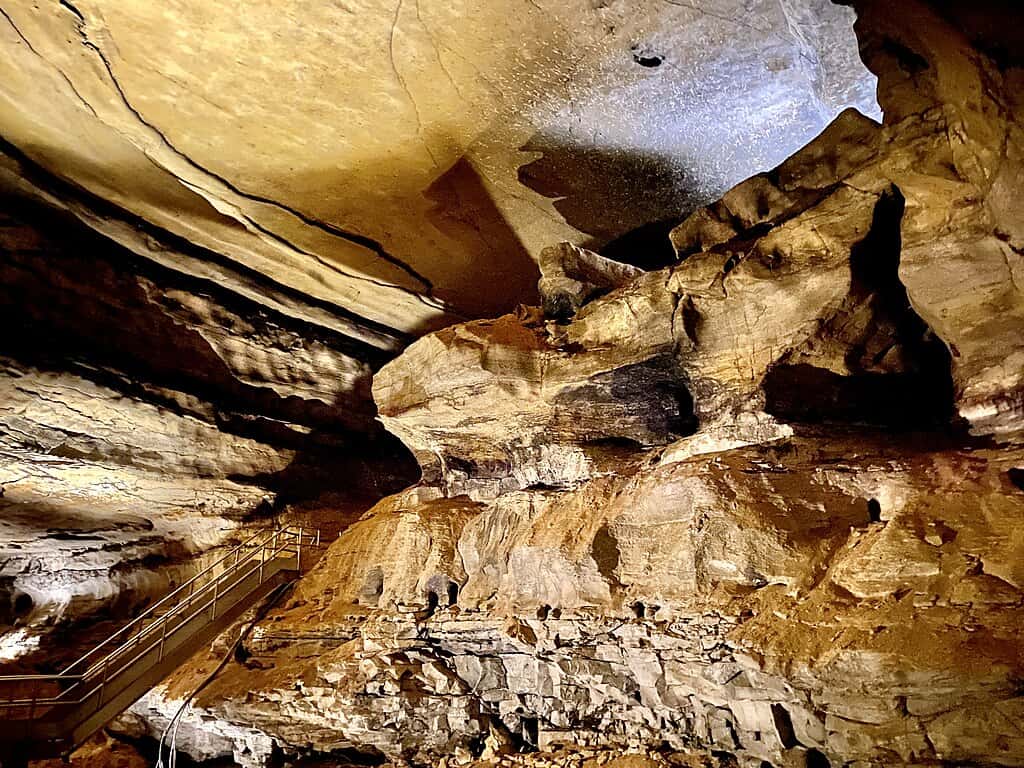 w_lemay, CC BY-SA 2.0, via Wikimedia Commons
Mammoth Cave National Park is home to the world’s longest cave and is such an interesting place from geological and human history perspectives. Most guided Mammoth Cave tours take 1-3 hours, plus you’ll want some time to explore the Cedar Sink Trail that leads to a massive sinkhole.
Mammoth Cave Tour
To enter Mammoth Cave, buy a tour ticket online in advance (tickets sell out fast). Choose from a self-guided Discovery Tour at your own pace or opt for a longer, guided tour to learn about the formations like domes, slot canyons, stalagmites, and stalactites.
Some of the tours offered include:
- Self-Guided Discovery Tour (30 minutes)
- Frozen Niagara Tour (1.25 hours)
- Domes & Dripstones Tour (2 hours)
- Historic Tour (2 hours)
- Extended Historic Tour (2.25 hours)
- Violet City Lantern Tour (3 hours)
You’ll have plenty of time to do the 2-hour Historic Tour — the earliest 10:00 a.m. (CST) tour is the one you want. This tour is moderately difficult with about 540 steps to climb and descend over a 2-mile distance.
Explore the tunnels used by prehistoric civilizations, opening up to cavernous rooms and tight spots that test your mettle deep within the cave. Along the way, your guide will explain the cave’s immense history through the different rooms, tunnels, and formations.
Make reservations 1-3 months from your trip, especially if you’re traveling during summer or early fall. Arrive 30 minutes before your tour time.
Cedar Sink Trail
Finishing up the tour around 1:00 p.m., head to the Cedar Sink Trailhead for a quick and beautiful 1-mile hike. The lollipop trail leads down a series of staircases through cedar forest to gaping sinkholes that fill with water. It’s roughly an hour and you’re likely to see deer on the trail!
Hop in the car to make the 4.5-hour journey to St. Louis, MO. Hyatt Regency St. Louis At the Arch and Drury Plaza Hotel St. Louis At the Arch are great options nearby to stay for the night and visit the famous Gateway Arch National Park tomorrow.

Day 3: Gateway Arch National Park & Oregon Trail Visit
Gateway Arch National Park surrounds the famous Gateway Arch that has been proudly standing as a mid-century modern beacon of American pride since 1965. This massive, 630’ arch is as wide as it is tall, making it a true national wonder.
Be smart and buy your tickets in advance so you can ride the tram all the way up to the top! You can select your ticket time. For this itinerary, the 9:10 a.m. slot is perfect. You’ll go through security before the tour, so allow about 30 minutes for that process.
Museum at the Gateway Arch
Try to arrive in time to visit the Museum at the Gateway Arch before your tram ride. It’s a great collection of exhibits highlighting the historic city of St. Louis and the building and inspiration for the arch.
Tram Ride to the Top Tour
Go to the north or south entrance at the time on your ticket. You’ll be guided through some exhibits featuring trivia and vintage animation shorts featuring the arch before you board the tram.
The scenic ride to the top takes about 4 minutes, and you’ll have some time to enjoy the amazing views over St. Louis and the Mississippi River from the observation deck windows.
Expect the tour to last up to 1 hour. Afterward, grab a bite to eat at the Paddlewheel Cafe right on the banks of the river.
Santa Fe Trail Park Wagon Ruts
With plenty of daylight left, make the 4-hour drive from St. Louis to the Prairie Village Santa Fe Trail Park just outside of Kansas City to see real wagon ruts on a section of the Oregon National Historic Trail.
Today, the wagon ruts have smoothed out into “swales,” or rounded depressions in the ground along the old Oregon Trail. Wander along the path and see the “Prairie Village Ruts” — impressions that thousands of wagon wheels, oxen, and cattle left on the trail.
Drive on to Lincoln, NE (about 3 hours and 15 minutes) to spend the night in a hotel before hitting the road early in the morning on your way to Chimney Rock National Historic Site and Rocky Mountain National Park.
Day 4: Chimney Rock National Historic Site
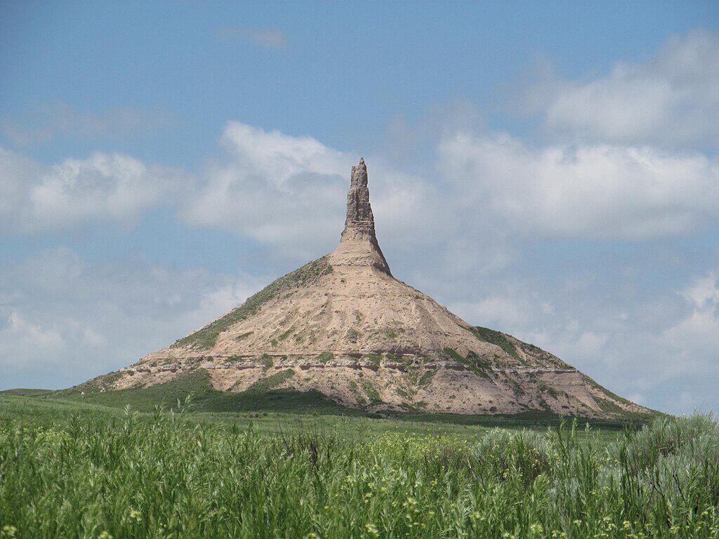 Dougtone, CC BY-SA 2.0, via Wikimedia Commons
The drive to Chimney Rock National Historic Site takes about 5 hours and 45 minutes from Lincoln, NE. This makes a great pit stop on your way to Rocky Mountain National Park as an incredible pillar rock formation that resembles a chimney juts out of the ground at the end of a half-mile trail. Check out this video to see more of what roadtripping this area looks like.
Chimney Rock is a well-known landmark in the West, located on the Oregon Trail and a time-honored symbol of the pioneers’ migration. The chimney rises over 300’ high and you can see it come into view when you’re still miles away.
It’s under 2 miles south of Highway 92 on Chimney Rock Road. To reach the rock, walk along the 0.5-mile trail to the viewpoint. It’s impressive in stature, although it’s been weathered and eroded quite a bit over the years.
There’s a visitor center with a little museum that’s packed with exhibits on the Western migration. Hit Log Cabin Restaurant & Lounge in nearby Gering on your way out for lunch and some of the best pies in the state!
Drive on to Estes Park, CO (about 3.5 hours) to settle into your accommodations just outside Rocky Mountain National Park.
Day 5: Rocky Mountain National Park’s Deer Mountain Trail & Trail Ridge Road Drive
Drive from Estes Park to the Beaver Meadows Entrance of Rocky Mountain National Park, your playground for the next 3 days! Stop by the Beaver Meadows Visitor Center for maps and information on this park with elevations up to 14,259’ (Longs Peak) in the Rocky Mountains of northern Colorado.
This alpine terrain is a patchwork of majestic mountain peaks, tundra, coniferous forests, and mighty rivers that make the landscape particularly striking. The Continental Divide runs through the park. Its 415 square miles are home to abundant wildlife: elk, moose, black bears, mountain lions, and bighorn sheep.
A couple of things to note:
- You need a Timed Entry Permit or service reservation for camping, horseback riding, tour, etc. between May 24 and October 20 to enter between 9 a.m. and 3 p.m.
- Grab a park pass or pay an entrance fee for your vehicle.
- Watch for altitude sickness symptoms (lightheadedness, headache, shortness of breath, nausea, fatigue), avoid alcohol, and drink lots of water.
Deer Mountain Trail
Pack a picnic lunch and follow Highway 36 (Park Entrance Road) for 15 minutes to reach the Deer Mountain Trailhead. This is a fantastic 6-mile trail of moderate difficulty that offers some of the best all-around views of the park. Plan on about 3.5 hours to hike it.
You’ll gain almost 1,400’ in elevation on this rewarding out-and-back hike. There are plenty of spots to step off the trail and take in the views of the surrounding mountains and forests. You might see elk, sheep, and chipmunks on the way!
From the beginning of the trail, you’ll be treated to views of Longs Peak (the highest mountain in the park) and then head into the forest as you rise up to the summit of Deer Mountain. At the top, you’ll see the splendor of the park stretching out for miles around you.
You’re doing the Deer Mountain Trail first today because afternoon storms are very common at this elevation. Still, bring some rain gear and a warm jacket because the weather changes quickly this high!
Scenic Trail Ridge Road Drive
Get back on the road, continuing west on the 48-mile Trail Ridge Road drive (about 4 hours total). It’s one of the best Rocky Mountain National Park attractions! Known as the “highway in the sky,” this is the highest road in the country.
Running between the eastern Estes Park to western Grand Lake, the road crosses the Continental Divide and leads you along the edge of streams, past stands of aspen, pine, and spruce trees blanketing mountain slopes, and incredible panoramic views of the park’s endless wilderness.
You’ll be able to spot wildlife (and wildflowers from late spring to summer) from your car, grazing in meadows and right off the road. This is one of my favorite places to take pictures in the park with so many scenic viewpoints, especially at sunrise.
There are tons of beautiful overlooks you can pull over for on the road:
- Beaver Ponds Boardwalk
- Many Parks Curve
- Rainbow Curve
- Forest Canyon
- Lava Cliffs
- Gore Range
- Medicine Bow
- Continental Divide
- Fairview Curve
Lake Irene Picnic Area (past the Continental Divide) is a gorgeous spot to whip out the lunch you’ve packed and enjoy it with mountain views surrounding you. Turn around when you reach Grand Lake to make the return trip.

Day 6: Bear Lake Corridor Hiking Trails or Ouzel Falls
Bear Lake Corridor has some of the best hiking trails in the park, but special entry requirements and limited parking make the park’s shuttle the best option to enter. Park at the Estes Park Visitor Center and board the free shuttle into the park at 6:30 a.m.
Once you’re in the park, board the next shuttle to Bear Lake Corridor. The shuttle runs every 10-15 minutes from late May to mid-October with the last ride at 7:30 p.m.
You have the option to do so many cool hikes from this part of the park, so decide if you’re up for a challenge or want to do a series of shorter easy and moderate hikes.
Short Bear Lake Hikes
- Bear Lake Loop (0.6 miles): Low elevation gain with great views of the crystal-clear water of Bear Lake
- Alberta Falls (1.6 miles): Low elevation gain with a scenic viewpoint at Alberta Falls
Moderate to Hard Bear Lake Hikes
- 5-Lake Trail Loop (7.2 miles): 1,351’ elevation gain to reach Bear, Nymph, Dream, Emerald, and Haiyaha lakes on a moderate loop with great mountain views
- Bierstadt Lake via Bear Lake & Flattop Mountain Trail (4.4 miles): 649’ elevation gain with about 2 hours’ hike time to reach Bierstadt Lake
- Hallett Peak (9.7 miles): 3,270’ elevation gain for experienced hikers through forest and up Hallett Peak with great lake overlooks and mountain views; plan on 8 hours or so
If you’re not fully acclimated to the altitude or don’t hike often, stick with the easy and moderate hikes here. Starting at such a high elevation, even moderate elevation gains can be difficult.
Board the shuttle back to the park and Estes Visitor Center after your day hike and rest up for your final day in the park tomorrow.
Alternative: Ouzel Falls
You can hike to Ouzel Falls on the Wild Basin Trail for a stunning sight that includes unnamed falls, Calypso Cascades, and the namesake Ouzel Falls. Wildflowers, wildlife, and roaring water make this one of the best trails in the park!
The moderate trail is 5.4 miles round-trip and takes about 2.5 hours to hike. You’ll rise 870’ to reach the highest elevation on the trail at 9,370’. From Estes Park, drive 12.6 miles south on Highway 7 to the Wild Basin Road junction and make a right, then turn right after 0.4 miles and drive 2.2 miles further to reach the trailhead.
You’ll see Lower Copeland Falls first, then Upper Copeland Falls soon after. Take the side trail to get close to both and return to the main trail. You’ll cross over Sandbeach Creek and continue left at the junction that splits off to backcountry campsites.
Pass an unnamed waterfall and start looking for the 200’ Calypso Cascades, which are more impressive during the spring and early summer. As you rise above the cascades, look for Longs Peak and Mt. Meeker looming in the north.
Now you’ll come to Ouzel Falls, tumbling 40’ down with options to view it from a footbridge. Get off the trail for a minute to access the best views of the falls (there may be dead trees in the way of the less-trodden “side trail”).

Day 7: Kawuneeche Valley, Coyote Valley Trail & Historic Site
The stunning Kawuneeche Valley near Grand Lake is the perfect place to spend your last day here. Keep an eye out for moose and elk wading the river or grazing in meadows in this part of the park!
Coyote Valley Trail
This easy, wide trail follows the Colorado River and is just 1.3 miles out-and-back, offering a chance to take in the beauty of the valley with lush meadows that make spotting wildlife almost guaranteed. Setting out early increases your odds.
Holzwarth Historic Site
On your way back from the trail, you’ll pass the Holzwarth Historic Site. Once a guest ranch, the original buildings and cabins are still here. Follow the short trail that leads along the Colorado River with mountain views to see more.
Now it’s time to get on the road to Arches National Park! It’s a 6.5-hour drive, so you’ll be there in time to get to your lodging and grab dinner in nearby Moab, UT (5 miles from the park entrance).

Day 8: Arches National Park’s Balanced Rock, Delicate Arch & Fiery Furnace
Utah’s Arches National Park is a true gem, showcasing natural rock arch formations and unique geologic forms that you won’t find anywhere else. With more than 2,000 rock arches, rock fins, balanced stones, and pinnacles in the park, it’s a must-visit on your coast to coast national parks road trip.
Timed Entry Reservations are required between April and October, so grab yours and a park pass or pay the entry fee in advance to enter the park.
La Sal Mountains Viewpoint & Visitor Center Nature Trail
This overlook gives you perspective on what you’re about to see in the park — pillars, arches, red rock everywhere and the endless skies above. Take a short walk from the parking area to see this thrilling panorama of Arches and all it entails.
Do the short Arches Visitor Center Nature Trail as soon as you arrive at the Visitor Center — it’s just 150 feet, leads you to some cool desert plant life, and takes about 10 minutes.
Great Places to stay in Moab Utah
Arches National Park Road Scenic Drive
Drive past the Visitor Center to start seeing more formations come into view. Three Gossips, The Organ, Sheep Rock, and Tower of Babel are in the Courthouse Towers area here near the park’s entrance. Three Gossips is one of my favorites with its 350’ tall sandstone figures appearing like people standing around chatting!
You can get closer to these formations on the Park Avenue Trail, or keep driving to get to the Courthouse Towers Viewpoint and cover more ground.
Continuing on, you’ll pass the Great Wall right next to the road with flat rock faces standing tall like a rugged wall. The Phallus Pillar and the Rock Pinnacles are just a bit further down the road.
Balanced Rock Trail & Viewpoint
You’ll reach one of the coolest areas in the park: Balanced Rock! This sandstone giant perches on a pedestal and seems to reflect the sunlight. There’s no better way to view it than from right below its base.
Follow the 0.3-mile trail from the road and parking lot to get close to Balanced Rock. The trail loops around the formation and takes just 15-30 minutes to complete with time to admire and take photos.
Delicate Arch Trail & Viewpoint
Turn right onto Delicate Arch Road to see the most famous formation in the park. Delicate Arch can be seen across a canyon, rising out of the ground in an arch shape sculpted over millennia from sandstone. Plan on 30-45 minutes for this stop in all.
Guided Fiery Furnace Hike
Plan ahead to book a guided ranger tour through the Fiery Furnace area or reserve a permit to hike it on your own through Recreation.gov. The area features canyons, cliffs, and narrow passageways through sandstone and is one of the best parts of the park to hike. Our founder Alice has done this hike, watch as she tries to navigate the slot canyon solo.
Ranger-led hikes take about 2.5 hours and are strenuous, with lots of climbing and scrambling over rocks. Bring at least a quart of water and sturdy, comfortable hiking shoes!
After your scenic drive and hike, stay in Moab, UT for the night to rest up for your 5-hour drive to Great Basin National Park in Nevada tomorrow.
Stay longer in Utah and explore all 5 Utah National Parks on this Mighty 5 Roadtrip
 John Manard, CC BY-SA 2.0, via Wikimedia Commons
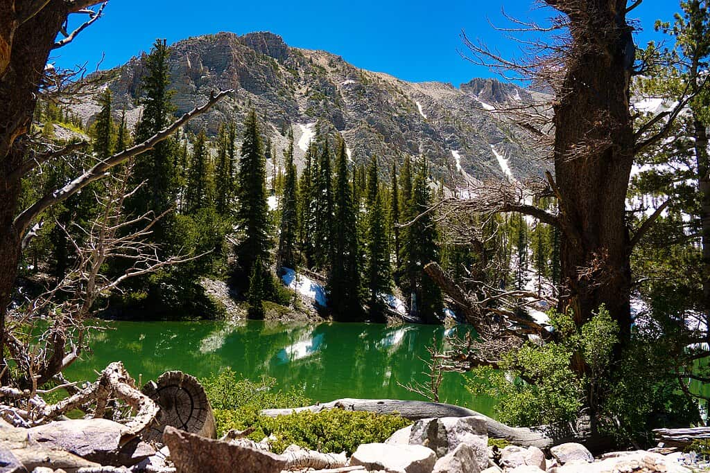
Day 9: Great Basin National Park’s Wheeler Peak Drive & Sky Island Forest Trail
No coast to coast national parks road trip is complete without a stop in Great Basin National Park! Situated near the Utah-Nevada border, the terrain spans desert and mountains with famed scenic drives, mountain trails, caves, and bristlecone forests to explore.
Camping in the park is great, but infrastructure projects have moved all campgrounds to a first-come, first-served basis (except Grey Cliffs Campground’s C Loop sites). Stay in nearby Baker, the gateway town to the park, instead.
Wheeler Peak Scenic Drive
Get a sense of what this park offers with the 12-mile Wheeler Peak Scenic Drive, just inside the park’s entrance to the right. With mountain peaks around you, the curving road stretching out before you, and vast deserts and sagebrush on either side, it’s a fantastic way to get introduced to Great Basin.
The drive takes about 30 minutes if you don’t stop, but you’ll want to pull over at the various overlooks along the way to see the South Snake Mountains and desert landscapes. You’ll climb to more than 10,000’ on this journey!
Do the self-guided auto tour, available on the official National Park Services app.
Sky Island Forest Trail
At the end of the scenic drive, you’ll come to the Bristlecone Trailhead where you can stretch your legs and get closer to the park’s unique plants and wildlife on the Sky Island Forest Trail. It’s just a quarter-mile long and easy to travel with a boardwalk section part way in.
Look for Wheeler Peak through the trees, admire wildflowers growing in streamside meadows, and enjoy a quick jaunt on your first day in the park. Head back to your lodging for the night and do more hiking tomorrow!
 Famartin, CC BY-SA 4.0, via Wikimedia Commons
Day 10: Great Basin National Park’s Bristlecone Pine Trail & Lehman Caves
Today, you’ll hike the Bristlecone Pine Glacier Trail, explore the Lehman Caves and Visitor Center, then take a short nature trail hike to discover the flora and fauna around the caves.
Bristlecone Pine Glacier Trail
This 3.7-mile out-and-back trail is the most popular in the park. It’s a moderately difficult trail that takes about 2 hours to hike. With some steep zones and amazing views of mountains, Theresa Lake, and the Wheeler Base Glacier, it’s well worth the effort and 793’ elevation gain.
You can do just the Bristlecone Pines segment or continue further along to the Glacier Trail to see the Wheeler Base Glacier (not quite as impressive as other national park glaciers, but still cool).
Theresa Lake (additional 0.2 miles) is beautiful and you’ll see tons of unique, gnarled bristlecone pines along the entire trail. From a lake and mountain views to the glacier, this is a hike that packs a lot of scenery in!
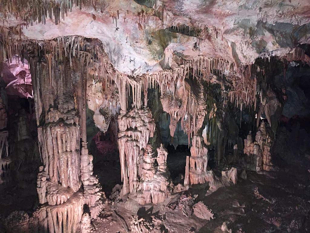
Lehman Caves Tour
Lehman Cave tours are the only way to explore the longest cave system in Nevada. You’ll need to buy tickets in advance and arrive at least 5 minutes before your tour time to check in. Choose one of three tours:
- Gothic Palace (summer; 30 minutes; easy)
- Lodge Room (year-round; 60 minutes; easy-moderate)
- Grand Palace (summer; 90 minutes; moderate-strenuous)
Inside the cave, you’ll tour the passages and get a look at the unique formations of the marble caverns, including special stalactites and cave shields. The 1-hour Lodge Room tour is a great option.
Lehman Caves Visitor Center Mountain View Nature Trail
Explore the Lehman Caves Visitor Center before or after your cave tour. From here, you can take a short 0.4-mile nature trail loop that runs around the area to see the flora and fauna of the area, all marked with descriptions. This easy hike takes about 10 minutes and is a great way to end the day.
It’s a long trip (10.5 hours) to Sequoia National Park, so set out this afternoon after your cave tour and nature trail walk to drive part of the distance and stay near Henderson, NV or Las Vegas, NV (about 5 hours away).

Day 11: Sequoia National Park’s Giant Forest & Tokopah Falls
Finish driving to Sequoia National Park — about 5.5 more hours — and start your day here with a bang. This 631 square mile park sits in the Sierra Nevada mountains and boasts beautiful peaks, waterfalls, lakes, meadows, and — of course — giant sequoia groves.
You’ll pay a vehicle entrance fee to get your pass into the park. The park is divided into 3 sections:
- Foothills
- Mineral King
- Giant Forest & Lodgepole
Arrive through the Three Rivers (Ash Mountain) entrance from Highway 198. There are tons of hotels and lodging options in Three Rivers, just minutes from the entrance. Book your room in advance.
Giant Forest gives you the most incredible experience since you’re only spending a day in the park. Drive 16 miles north of the Ash Mountain entrance on Highway 16 to reach the Giant Forest.
Giant Forest Museum
In the midst of this famous sequoia grove, you can explore this historic museum and discover facts about the massive trees that stand around you. Come before you head out into the grove so you’ll understand the significance of the trees you’re seeing!
Big Trees Trail
From the Giant Forest Museum, head out on the Big Trees Trail on a 0.75-mile path (allow 1 hour) lined with colorful illustrations depicting sequoia facts. The trail encircles Round Meadow and you’ll feel dwarfed by these giant trees on the way!
General Sherman Tree
You’ve got to see the General Sherman sequoia. This is the biggest known living single-stem tree on the planet! The trail to the tree begins from the main parking area off Wolverton Road. It’s a high-elevation hike, so take it slow and descend the stairs on this 0.5-mile trail to reach the tree.
Moro Rock
Another awesome hike that’s more challenging is the Moro Rock hike, off Crescent Meadow Road near the Giant Forest Museum. Climb 350 steps to reach the top of the rock and suddenly, the Sierra Nevada mountains come into view with the beautiful San Joaquin Valley in front of you.
You’ll have a commanding view of the entire area. Handrails make it feel safer up here! Plan on anywhere from 30 minutes to 2 hours to complete this strenuous climb and descent.
Tokopah Falls
Tokopah Falls is close to the Lodgepole Campground, across the Marble Fork Bridge. Spanning 1.7 miles, it’s an easy trail along the Kaweah River that leads to great views of cliffs and Tokopah Falls tumbling over a canyon.
The falls plunge 1,200’ down and really rage in summertime (try to come around June if possible). Stay in Three Rivers for the night and set out for Yosemite tomorrow.
If you’re looking for more details on planning a trip to Sequoia and Kings Canyon check out this planning guide to Sequoia National Park.

Day 12: Yosemite National Park’s Valley Floor & Mirror Lake
It’s about 2.5 hours to reach Yosemite National Park. This park is so iconic, wild, and majestic that words don’t do it justice. Coming here, it’s so hard to narrow down a 2-3 day itinerary with so many amazing sights and areas to explore.
If you love watching videos that make your heart race, Alice Ford (the founder of this site and avid adventurer) shared a video of her short but ambitious solo backpacking trip where she conquered Half Dome!
Two days allows enough time for a memorable hike and seeing highlights of this 1,200 square mile UNESCO World Heritage Site.
You’ll need reservations to drive into the park between mid-April and late October; requirements vary by the month and day, so check online to be sure for your trip dates.
Entrance and Glacier Point
Come through the Fish Camp entrance on Highway 41. Look for the Wawona Victorian Hotel (you can stay here!). Make the drive to Glacier Point (1 hour) along Highway 41 for incredible views over the Yosemite Valley, including the imposing Half Dome.
Valley Floor Tour
If you don’t want to spare the hour for a drive, head right down into the Valley Floor for a tour. Valley Floor Tours and hop-on, hop-off tours leave multiple times each day and carry you to some of the park’s coolest spots: views of Half Dome and El Capitan, Yosemite Falls, Bridalveil Fall, Tunnel View, and more. It’s about 2 hours to see a lot of what makes Yosemite special.
Mirror Lake Hike
After the tour, take a short 2-mile round-trip hike to Mirror Lake to get closer to the natural beauty of the valley. You’ll wonder at the sight of the glass-like water, ringed by mountain views and evergreen in Tenaya Canyon.
Yosemite Village
The village is home to the Yosemite Museum, Ansel Adams Gallery, great spots for lunch or dinner, and the historic Ahwahnee Hotel. Spend a little time exploring before heading to your lodging in or just outside the park and prepare for a packed day tomorrow!

Day 13: Yosemite National Park’s Waterfalls and Mist Trail Loop
Hiking trails, waterfalls, amazing rock formations, and panoramic views are the plan for Day 2 in the park. You’ve got lots of options for shorter, easy hikes on the Valley Floor:
- Lower Yosemite Falls (1.2-mile loop): About 25 minutes total for a paved walk to the 320’ Lower Yosemite Fall
- Bridalveil Fall (0.08-miles): Scenic out-and-back paved trail with options to climb closer to the fall on rocks
- Cook’s Meadow Trail (2-mile loop): Easy trail with views of Half Dome, Yosemite Falls, Sentinel Rock, and Glacier Point from the Valley Floor
Mist Trail to Vernal Fall
Once you’ve hiked one or more of the short and easy trails, amp things up a little with the Mist Trail. This hike leads you along the Merced River from Happy Isles in the valley to Vernal Fall. Getting to the base of Vernal Fall is roughly 2 miles round-trip — you could continue to see more waterfalls, but to save time for the Tioga Pass drive, turn around here.
Drive Scenic Tioga Pass
Tioga Pass is the most famous scenic road trip through Yosemite and you can’t skip this part of the road trip! Dedicate about 4.5 hours total for the drive with time to pull over at viewpoints.
The road opens in late May and closes around November each year. It spans 46 miles of gorgeous terrain, offering views of Yosemite’s valleys, waterfalls, rock formations, and canyons. Scenic viewpoints along the way include Olmstead Point, Vista Point, Tenaya Lake, and Tuolumne Meadows.
You’ll be able to spot seasonal waterfalls right on the side of the road during the spring and summer! This drive will be a highlight of your trip, so take your time and soak in the views.
Day 14: Mariposa Grove and Head Home
Yosemite’s sequoia groves are incredible. See the giants towering in the Mariposa Grove on your way out of the park! Take a shuttle from the Mariposa Grove Welcome Plaza. You’ll see trees like Bachelor and Three Graces, the California Tunnel Tree, and Fallen Monarch in this otherworldly grove.
Spend a little time exploring among these gigantic trees before heading to the Fresno-Yosemite International Airport (1.5 hours) or driving to return home.
Take an Incredible 14-Day Coast to Coast Journey
Road tripping across the country has such a classic American feel, and national park-hopping makes it even more enjoyable. With tons of great hikes, long-spanning history, stunning views, and beautiful landscapes to explore, this trip is going to be one for the books. Never Stop Exploring!
Pin this article!


0 Comments