
The Definitive Capitol Reef National Park Guide
I’m Alice, and I’ll Be Your Capitol Reef National Park Guide
Capitol Reef National Park is Utah’s best-kept secret. If you’re here, maybe you’re already in on it—and I can tell you that of all the adventures I’ve taken, this is one of the coolest places I’ve been in the United States.
But like some of the headliner Utah destinations including the other Utah Mighty 5, exploring this park takes a little research, planning, and experience. I couldn’t find a great guide for all the things I wanted to do in the park, so I created an itinerary and learned along the way. I’m sharing my exact trip plans with you here so you can recreate the unforgettable hikes, drives, and experiences I had adventuring through this park.
We’ll start with some basics and background info, then I’ll show you the trails, roads, and activities you shouldn’t skip while you’re in town. Trust me. The sheer scale and beauty of this place is going to blow your mind!
Psst: I may add affiliate links throughout this post—they don’t cost you a thing, but help me keep the lights on around here! It just means if you see something you like, I’ll earn a small commission from your purchase.
Where is Capitol Reef National Park?
Capitol Reef National Park is in southern-central Utah. It’s red rock country here, so you’ll see all the desert landscapes and rugged topography you’d expect to find in Moab. Speaking of Moab, Capitol Reef is roughly a 2.5 to 3-hour drive (about 140 miles) south of Moab when you take US-191 S and UT-24 W.
I really recommend this scenic route if you’re visiting both places. It takes you through the heart of the red rock landscape and gives you a tantalizing preview of the geological wonders that are waiting for you inside the park.

-
- 👉 Find the perfect hotel
- 🚗 Rent a Car
- 🥾 Find a nearby Trail
- 🧳 Pack the perfect suitcase with these packing cubes
- 👉 All the gear you need for your adventure
- 📱Grab an E-Sim for travel abroad
Why Capitol Reef is a Must-Visit Park
Capitol Reef is used to being overshadowed by its more famous neighbors, like Zion and Arches. That’s okay, because this park offers a quieter, just-as-captivating experience without the crowds.
The park’s eye-catching geological features, interesting history, and dream-like landscapes make it a haven for solitude and discovery—whatever you’re seeking, you’ll probably find it here. Here are 3 reasons it’s worth visiting Capitol Reef National Park.
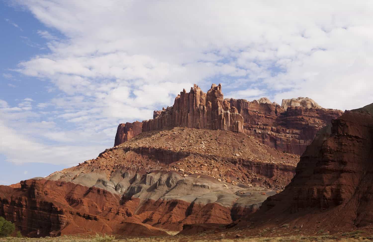
1. The Geology
The Waterpocket Fold is at the heart of Capitol Reef. This is a nearly 100-mile long monocline—it’s a type of fold in the Earth’s crust where rock layers are tilt in one direction. What you’re looking at here was formed over 50 million years ago during the Laramide Orogeny.
Yes, it’s dramatic. Yes, it’s a photographer’s dream. It’s one of the strangest landscapes I have ever seen.
It showcases layers of Navajo Sandstone, Carmel Formation, and other geological formations, so what you see is a genuinely striking visual contrast that lets you know what a magical place you’ve entered.

2. The History
Capitol Reef isn’t just a geological wonder. It’s also a cultural crossroads with a long history that seems straight out of a movie. Before it was a national park, this land was home to the Fremont people. They left behind petroglyphs carved into the canyon walls. These stylized figures—bighorn sheep, spirals, human-like shapes—still speak to us from over 1,000 years ago.
In the late 1800s, Mormon settlers established the Fruita community in the heart of the park. They planted orchards, built irrigation ditches, and even set up a one-room schoolhouse that still stands today. Unlike other boomtowns in the West, Fruita never got very big. But its quiet, productive presence left a lasting mark on the landscape. The orchards are still maintained by the National Park Service, and you can even harvest fruit when it’s in season.
What’s so compelling here is the sense of time. You can walk the same land used by ancient peoples, pass homesteads that once raised families in a harsh desert climate, and it all blends seamlessly with the monumental rock formations towering above.
This isn’t just a park. It’s a living timeline.
3. The Landscapes
Capitol Reef’s scenery is almost alien. The park features high-desert plateaus, narrow slot canyons, sculpted rock domes, and rainbow-colored hills. And honestly, that’s just scratching the surface.
Drive or hike just a few miles and the environment shifts completely. One moment you’re weaving through the deep, shaded walls of Grand Wash, the next you’re climbing to panoramic views from Cassidy Arch. Then there’s the Cathedral Valley, where massive sandstone monoliths known as the Temples of the Sun and Moon rise from a barren desert floor like ancient ruins. They feel mythic.
And then there are the Bentonite Hills: they’re soft, rounded, and layered in purples, reds, and grays. Your view here looks like something from Mars than Utah. You’ll find only a few places on Earth with such a variety of surreal landscapes packed into one park. And it’s right here in the U.S.!

The Everything-You-Need Capitol Reef National Park Guide
Capitol Reef might be the quietest of Utah’s Mighty 5, but there’s no shortage of things to explore here. If you want the must-do hikes (including hidden gems and easy favorites), the scenic drives you won’t want to miss, and the park’s fascinating human history, I’ve done my best to cover it all in detail.
I’ll also talk about the best times of year to visit, where to camp (both in and outside the park), and a few off-the-beaten-path wonders nearby that are absolutely worth your time.
Whether you’re pulling up in a rugged 4×4 or a trusty rental car, planning a family-friendly stop or a full-on backcountry adventure, this guide will help you make the most of your time in Capitol Reef. Let’s get into it.
What’s the Best Time to Visit Capitol Reef?
I found that the sweet spot for visiting Capitol Reef is up in the air—it’s between spring (April–June) and fall (September–October). During these periods, the temperatures are mild, skies are mostly clear, and the trails are in prime condition for hiking and exploring.
Summer can bring intense heat, especially in exposed areas like Grand Wash or the Burr Trail. If you’re traveling in summer, plan on early mornings and lots of water to make the most of the trip. That said, it’s still a popular time, and the higher elevations can still offer some reprieve from the heat.
Winter is typically when you’ll see fewer visitors and encounter a peaceful, snow-dusted landscape. While some roads and trails can be icy or muddy, this is a great time for solitude (if you’re prepared for colder conditions).
If you’re aiming to harvest fruit in the park’s historic orchards, July through September is your window. Just check with the park for what’s in season before you set out!
Capitol Reef National Park Guide to Hiking Trails
You can take a short walk to a jaw-dropping overlook or go for a leg-burning climb to high-elevation views. No matter what your hiking style is, I can tell you that Capitol Reef delivers.
Walk among the natural arches, plunge into deep canyons, and get your fill of panoramic vistas. There’s just enough variety to make you start planning your next trip before you even leave the park.
On my last trip, I made sure to squeeze in these 4 standout hikes. They definitely belong on your itinerary.
- Hickman Bridge Trail: Moderate 0.9-mile hike leading to a 133-foot natural bridge and canyon views.
- Grand Wash Trail: Easy 2.2-mile hike through a narrow canyon, just right for families and beginners.
- Cassidy Arch Trail: Strenuous 1.7-mile hike that rewards with views of a massive arch and vistas.
- Navajo Knobs Trail: Challenging 4.7-mile hike with 360-degree views of every landscape in the park.
Hickman Bridge Trail
Distance: 1.8 miles round-trip | Difficulty: Moderate
This well-loved trail takes you gradually upward along a rocky path. You’ll pass through slickrock benches and beside a small Fremont-era granary before you arrive at Hickman Bridge. It’s a stunning 133-foot natural sandstone arch tucked into a canyon alcove. Look for sweeping views of the Fremont River Valley along the way! This is a great intro to the park’s geology and scenery. You can expect light crowds and plenty of photo ops as you go.
Grand Wash Trail
Distance: 4.4 miles round-trip | Difficulty: Easy
Grand Wash is like stepping into a natural hallway carved into the ancient stone. The trail follows a dry riverbed (please watch for flash flood warnings) through towering Navajo Sandstone canyon walls. Some of the walls narrow to just 20 feet across. It’s a flat, easy trek that’s great for families, photographers, or anyone looking for a casual stroll with high visual payoff. You can start from either the Scenic Drive or Highway 24. A shuttle or car drop-off makes a one-way hike possible.
Cassidy Arch Trail
Distance: 3.4 miles round-trip | Difficulty: Strenuous
Named after Butch Cassidy, who reportedly used the nearby canyons as a hideout, Cassidy Arch climbs quickly from the Capitol Gorge parking area and gains over 670 feet in elevation. The reward makes it so worth it! You’ll arrive to a dramatic overlook of the Cassidy Arch, and you can even stand above the arch itself. The route includes some exposed sections on slickrock, so bring good shoes and water. It’s one of the park’s most iconic and rewarding hikes.
Navajo Knobs Trail
Distance: 9.4 miles round-trip | Difficulty: Challenging
This is a longer, more demanding hike, but if you’ve got the stamina, I urge you to go for it. The trail begins at the same trailhead as Hickman Bridge, passes the Rim Overlook, and continues climbing to the Navajo Knobs. It’s a towering viewpoint with 360-degree panoramas across the Waterpocket Fold, Fruita, and red rock spires rising in the distance. Bring plenty of water, sunscreen, and snacks. It’s an all-day kind of hike with all-time kind of views.
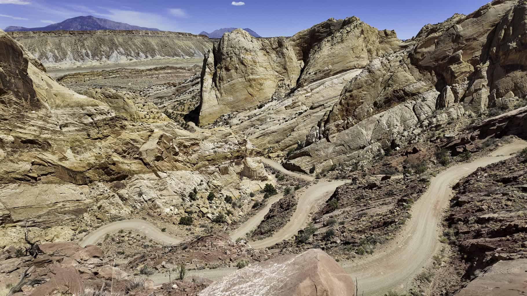
Scenic Drives You Won’t Want to Miss in Capitol Reef
Capitol Reef is a park made for driving. Windows down, sunshine, gorgeous views—get your best playlist ready! Whether you’re behind the wheel of a high-clearance 4×4 or an economic rental, there are routes out here that take you deep into the park’s surreal landscapes with no long hikes required. These scenic drives are great places to access to hidden gems, uncover some of the best views, and approach some of the most photogenic terrain in the Southwest.
1. Scenic Drive
Distance: 7.9 miles one way | Vehicle Requirements: None
This paved route starts in the Fruita Historic District and takes you south along the base of the Waterpocket Fold. It’s great for anyone who’s short on time or looking for an easy way to experience the park’s views. You’ll pass the turnoffs for Grand Wash and Capitol Gorge, which are two easy, family-friendly hikes I recommend.
In 2024, this road was revamped after flood damage, so it’s now in great shape. You can extend your drive onto a graded dirt road that continues deeper into the Fold, if conditions are right.
2. Burr Trail
Distance: ~68 miles (from Boulder to Bullfrog) | Vehicle Requirements: High-clearance optional, but check weather
Starting in the town of Boulder, the Burr Trail slices through Grand Staircase-Escalante and the southern edge of Capitol Reef before it drops into Glen Canyon. The route winds through Long Canyon, descends to dramatic switchbacks into the Strike Valley, and passes a technicolor parade of bentonite hills.
It was originally built as a cattle route by rancher John Burr in the 1800s, but it’s now one of the most scenic drives in the entire region. The road is mostly paved but becomes gravel/dirt in Capitol Reef. Avoid it altogether in wet weather—it can become impassable fast.
3. Cathedral Valley Loop
Distance: ~58-mile loop | Vehicle Requirements: High-clearance, 2WD minimum
This remote, all-day loop is an awesome way to spend your final full day in the park. takes you through some of Capitol Reef’s most otherworldly landscapes. The stars of the show are the Temples of the Sun and Moon—two monolithic sandstone formations that rise starkly from the desert floor. You’ll also pass Glass Mountain, a gypsum crystal mound, and Bentonite Hills, known for their smooth, painted textures.
Start early, bring a full-size spare tire, and check the conditions before heading out. While doing the full loop requires high clearance, it’s possible to drive to the Temples and back in a standard SUV if you’re cautious.
It takes just over 90 minutes to get to the Temple of the Sun and Temple of the Moon from the Visitor Center. I was told 8 1/2 inches of clearance is needed, so trucks and Jeeps are ideal.

Historic Stops in Capitol Reef National Park
Capitol Reef’s story isn’t just told in stone. You’ll also find it literally etched into canyon walls and written into the legacy of those who called this place home. From ancient Indigenous cultures to pioneering settlers, the park is rich with human history that adds depth to its already dramatic landscapes. Here are two must-see stops that bring the past to life!
- Fruita Historic District: This began as a Mormon settlement (established in 1880), but now, Fruita is the center of Capitol Reef. Come explore the preserved schoolhouse, Gifford House, and walk through the sweet-smelling, shady orchards that are still maintained by the National Park Service
- The Gifford Homestead: Inside the Fruita district, the Gifford House is now a small museum and shop where you can buy local crafts and some famously delicious fruit pies (seasonally). The homestead was part of a 200-acre farmstead once run by the Gifford family, who lived here until 1969. It’s a great spot to understand pioneer life in a remote, self-sustaining community.
- Petroglyph Panel: Located near the Fruita Historic District, take a short walk to reach the rock walls that are adorned with Fremont people’s carvings. It’s a beautiful glimpse into the area’s ancient history.
- Capitol Gorge Pioneer Register: At the end of Capitol Gorge Road (access it via the Scenic Drive), a short hike leads you through a narrow canyon where early settlers and explorers carved their names into the rock, known as the “Pioneer Register.” While modern graffiti is a no-go, these historic inscriptions give a raw, personal glimpse into 19th-century travel through this rugged terrain.
- Behunin Cabin: Just off UT-24 near the eastern boundary of the park, this tiny, one-room stone cabin was built in the 1880s by Elijah Behunin, one of the earliest Mormon settlers in the area. He, his wife, and their 13 children (!) lived here—but not all at once. It’s a humbling reminder of the harsh conditions and resilience required to live in the desert.
Epic Photography Spots in the Park
Beyond the winding trails and scenic drives, Capitol Reef has a few standout features that feel like they belong on another planet and demand you pull your camera out. These spots are off the beaten path, but absolutely worth the effort for their sheer visual impact and beauty.
If you’re looking to be wowed—and maybe a little humbled by nature’s creativity—don’t miss these.
Glass Mountain
Near the Temples of the Sun and Moon in Cathedral Valley, Glass Mountain is a small but spectacular mound made entirely of selenite crystals (a form of gypsum). These glittering, translucent shards rise like a mineral iceberg from the desert floor. It’s delicate and out of this world. You can’t climb it (please don’t try—it’s fragile), but you can get up close and appreciate the raw geological weirdness.
📍 Access: Located just past the Temples of the Sun and Moon; best visited on a Cathedral Valley Loop drive.
Bentonite Hills
These soft, rounded hills look like something out of a painting, with their layered stripes of red, purple, gray, and blue. The hills were formed by volcanic ash deposits millions of years ago. The bentonite clay absorbs water and becomes incredibly slick—so don’t try to hike here in or after rain. They’re a photographer’s dream, especially during golden hour when the colors look darker with more contrast.
📍 Access: Located near the southern part of the Cathedral Valley Loop and also viewable off parts of Burr Trail Road.
Cosmic Ashtray
Also known as the “Sandstone Bowl” or “The Vortex,” this bizarre formation is a sandstone dome hollowed out by wind and erosion into a massive, circular depression filled with wind-blown sand. It’s surreal, remote, and requires some effort to reach, but the view into this perfectly sculpted geologic oddity is unforgettable.
📍 Access: Near the town of Escalante, technically outside Capitol Reef but within a reasonable day trip. The route requires navigation skills (no marked trail), high-clearance vehicle access, and possibly GPS guidance.
Where to Stay in Capitol Reef National Park: Camping & Beyond
Roll in with a tent, a van, or find your comfy bed after a long day on the trail—Capitol Reef has options. Camping inside the park puts you right in the action, especially near the Fruita Historic District, but there are also nearby towns with hotels, cabins, and inns if you’d rather sleep indoors. Here’s a quick Capitol Reef National Park guide on where to stay.
Capitol Reef Campground (Fruita Campground)
Right in the Fruita Historic District, this is the park’s main developed campground. It offers 71 sites with picnic tables, fire pits, and nearby restrooms (but no hookups). Sites operate on a first-come, first-served basis most of the year. Check the NPS website for seasonal updates. It fills up fast in spring and fall, so arrive early.
Cathedral Valley Campground
This primitive, high-clearance-access campground has just 6 sites and sits near the Temple of the Sun and Moon. There’s no water and minimal services, but if you’re looking for solitude and night skies, it doesn’t get much better. No fees, no reservations, and open year-round when the weather permits.
Dispersed Camping (BLM & National Forest Land)
Outside the park boundaries, you’ll find plenty of dispersed camping areas on Bureau of Land Management and U.S. Forest Service land. These are typically free, unmarked spots with no facilities, so bring everything you need and follow Leave No Trace guidelines. Be mindful of road conditions. Many of the access routes can get rough, fast in bad weather.
Lodging Options Outside the Park
If camping isn’t your thing (or the weather isn’t cooperating), you’ve got solid lodging options in nearby towns. These spots range from basic motels to rustic cabins and small inns:
- Torrey: The closest town to the park (just 10 minutes from the visitor center) with the widest variety of lodging and restaurants.
- Boulder: West of the park and near the Burr Trail, this quiet, scenic town is a good option if you’re heading toward Escalante or Grand Staircase.
- Hanksville: East of the park, closer to Cathedral Valley and Temple of the Sun/Moon. Remote but good base for the wilder side of Capitol Reef.
- Escalante: Farther away, but an option if you’re road-tripping through multiple parks, especially if you’re hitting the Cosmic Ashtray or Burr Trail.

What to Do Nearby
Capitol Reef may feel remote—that’s part of its charm—but there are plenty of incredible places just a short drive away. If you’re road-tripping through southern Utah or spending a few extra days in the area, these nearby spots are absolutely worth adding to your itinerary.
Here are a few more adventures just beyond the park boundaries.
Goblin Valley State Park
About 1.5 hours west of Capitol Reef, this park is packed with thousands of oddly shaped sandstone hoodoos—nicknamed “goblins”—that you’re free to wander among, just like in Bryce Canyon National Park! It’s a fantastic place for families, photographers, and anyone who enjoys bizarre geology. The park also has short hikes and is a fantastic dark sky destination if you’re staying overnight.
Anasazi State Park Museum
Roughly an hour west of the park in Boulder, this underrated stop explores the history of the Ancestral Puebloans who lived in the region. There’s a museum with artifacts and reconstructions, plus the remains of a 900-year-old village you can walk through. It’s a quick, educational detour if you’re driving the Burr Trail.
Factory Butte
Go about an hour east of the park near Hanksville to reach an isolated mesa that juts up from a flat desert plain. It looks totally out of place and is spectacular. Photographers, drone pilots (check current regulations), and off-road enthusiasts will love the area around Factory Butte—including the nearby Caineville Badlands. It’s a dramatic, lunar-like landscape of bentonite hills and stark cliffs.
Little Wild Horse & Bell Canyon Loop
One of the best non-technical slot canyon hikes in Utah is just 1.5 hours west of the park (near Goblin Valley). This 8-mile loop takes you through narrow, twisting sandstone canyons that are perfect spots to explore for adventurous hikers and families. Avoid it in summer storms (flash flood risks), but this place is unforgettable in good weather.
Take the Capitol Reef National Park Guide on the Road
It doesn’t get the fanfare, but Capitol Reef National Park really is a treasure trove of natural beauty, history, and adventure. Whether you’re hiking through canyons, driving scenic routes, or exploring historical sites, the park offers a unique experience that can thrill you (and fill your camera roll).
You know the geology, history, landscapes, and trails. You’re all set on the best time to go, where to stay, and what you can do nearby. So, pack your gear, hit the road, and take this Capitol Reef National Park guide on the road—and don’t forget to add an adventure or two of your own!
Pin Me


Do you know how much time it usually takes to get permits if needed?
Permits for which trail? Reservations for parks are made on recreation.gov or in person at the backcountry office.